Mensagens

A mostrar mensagens de maio, 2017

Chapter XI- Portugal in the World of Maritime Discoveries
Imagem
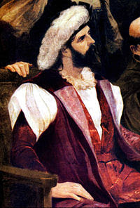
Portugal Discovers Brazil Picture 1- Pedro Álvares Cabral Pedro Álvares Cabral, a military commander, was the navigator who discovered Brazil, when his fleet set out for India in the year 1500, had the mission to recreate the route newly created by Vasco da Gama, to establish commercial relations and to return with Spices. However, its fleet of 13 ships has moved too far from the African coast, perhaps due to strong winds and sea currents, what is certain is that Pedro Álvares Cabral when landing in Brazil, thought to be only and only an island and Nicknamed her Vera Cruz (True Cross) Picture 2- Map of Brasil When exploring the coast of said island Álvares Cabral, he realized that at last he had discovered a Continent. He dispatched a ship to bring the good news to King Manuel I to inform him of his discovery, since the territory was within the limits imposed in the Tordesillas treaty, this territory was automatically considered Portuguese. The fleet refueled a...

Chapter X- Portugal in the World of Maritime Discoveries

Imagem
Portugal discovers China Picture 1- Jorge Àlvares Jorge Álvares, was a Portuguese explorer and the first European to arrive by sea to China in the year 1513 . In the same year he visited the present city of Hong Kong Upon his arrival in China, he soon established trading posts in the province of Guangzhou and later established a trading post in Macao. He came to build a shack that served as a haven for clandestine merchants on a beach on Sanchoon Island in China, It will have built the first Portuguese standard in China in Tamão (Hong Kong Portuguese) On July 8, 1521, Jorge Álvares died on the island of Sanchoon, China Picture 2- Map of China Picture 3- Sculpture of Portuguese navigator Jorge Álvares in Macau, China

Chapter IX- Portugal in the World of Maritime Discoveries

Imagem
Picture 1- Travel of Bartolomeu Dias King João II entrusted to the Portuguese navigator Bartolomeu Dias the mission to discover the maritime route to India and to seek and establish peaceful relations with the Emperor of Ethiopia.   Bartolomeu Dias, who was the 1st European to double the Cape of Storms, later nicknamed by John  (João ) II of Cape of Good Hope, situated in the extreme south of Africa, reaching the Indian Ocean, sailed away from the coast in the South Atlantic in 1488.   The purpose of this trip was to assess whether a sea route to India would be possible, and this trip indeed paved the way for the discovery of Vasco da Gama. Picture 2- Bartolomeu Dias Picture 3- Cape of Good Hope, South Africa Vasco da Gama was the Portuguese navigator who discovered the sea route to India. The task of traveling to India was initially attributed by King (João) John II to the father of Vasco da Gama, but with the death of 2, king D. Manuel I who ris...

Chapter VIII- Portugal in the World of Maritime Discoveries

Imagem
3rd Part ( S. Tomé and Principe, North  America and Canada ) In 1470 or 1472 Portuguese navigators: João de Santarém, Pêro Escobar and Fernão de Pó discovered the islands of S. Tomé, Ano-Bom and Príncipe. Ano-Bom is a small island that belongs to Equatorial Guinea. Picture 1- Map of S.Tomé and Príncipe Picture 2- S. Tomé and Príncipe North America João Vaz Corte- Real was a Portuguese navigator linked to the discovery of New Land   (Canada and USA) He was sent in 1473 by King Afonso V to Denmark to take part in an expedition to reach Greenland He organized trips that took him to North America, exploring the banks of the Hudson River (situated in New York) to Canada. Corte-Real will have arrived in North America 19 years before Christopher Columbus, but there is no documentary evidence and I will explain why: at the time of the discoveries the other kingdoms were busy with internal problems, to avoid competitiveness many of the Portug...

Chapter VII- Portugal in the World of Maritime Discoveries

Imagem
2nd part Guinea, Cape Verde, Congo and Angola In 1444 Dinis Dias doubles Cape Verde. Guinea was visited, and the southern limits of the Sahara desert were exceeded. In 1450 it was discovered the archipelago of Cape Verde Picture 1- Cape Verde Picture 2- Map of Cape Verde In 1460 the coast was explored to Sierra Leone, more than 2 thousand km of African coast, beyond the Bojador   Passing the Cape Bojador, the Portuguese navigators sailed in unknown seas and faced various dangers Picture 3- Portuguese Maritime Discoveries  The Portuguese navigator Diogo Cão arrives at the Congo Empire (an African region located in southwest Africa today corresponds to the north-west of Angola, including Cabinda, Republic of Congo and finally Gabon) and in 1485 Diogo Cão, arrives at Cape of the Cross, now Namibia . Diogo Cão Introduced the use Patterns in Stone, replacing with wooden crosses. Picture 4 - Diogo Cão  Picture ...